VLM-Loc: Localization in Point Cloud Maps via Vision-Language Models
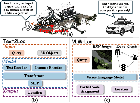
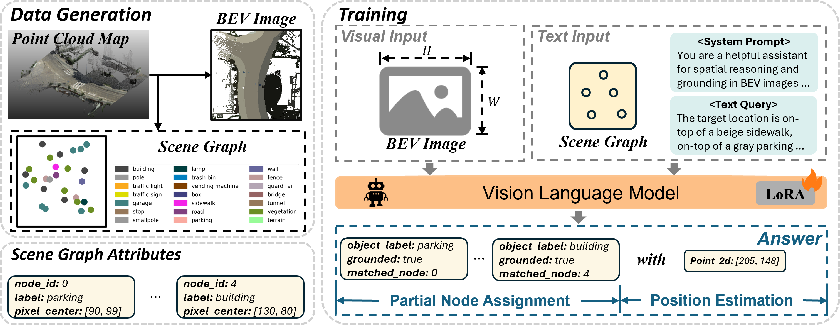
Abstract: Text-to-point-cloud (T2P) localization aims to infer precise spatial positions within 3D point cloud maps from natural language descriptions, reflecting how humans perceive and communicate spatial layouts through language. However, existing methods largely rely on shallow text-point cloud correspondence without effective spatial reasoning, limiting their accuracy in complex environments. To address this limitation, we propose VLM-Loc, a framework that leverages the spatial reasoning capability of large vision-LLMs (VLMs) for T2P localization. Specifically, we transform point clouds into bird's-eye-view (BEV) images and scene graphs that jointly encode geometric and semantic context, providing structured inputs for the VLM to learn cross-modal representations bridging linguistic and spatial semantics. On top of these representations, we introduce a partial node assignment mechanism that explicitly associates textual cues with scene graph nodes, enabling interpretable spatial reasoning for accurate localization. To facilitate systematic evaluation across diverse scenes, we present CityLoc, a benchmark built from multi-source point clouds for fine-grained T2P localization. Experiments on CityLoc demonstrate VLM-Loc achieves superior accuracy and robustness compared to state-of-the-art methods. Our code, model, and dataset are available at \href{https://github.com/MCG-NKU/nku-3d-vision}{repository}.




Paper Prompts
Sign up for free to create and run prompts on this paper using GPT-5.
Top Community Prompts
Explain it Like I'm 14
Plain-English Summary of “VLM-Loc: Localization in Point Cloud Maps via Vision-LLMs”
1) What is this paper about?
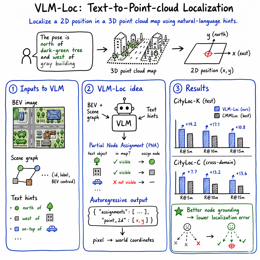
This paper is about teaching a computer to find a precise spot in a city map using only a short text description, like “I’m next to a blue bus stop, with a park to my left and a supermarket behind me.” The map isn’t a normal picture—it’s a 3D “point cloud,” which is like a huge collection of colored dots that form buildings, trees, roads, and more. The authors build a system called VLM-Loc that uses a powerful AI (a vision-LLM) to read the text, look at the map, and guess the exact location being described.
Why this matters: GPS can be inaccurate in cities (tall buildings block signals). Being able to localize from natural language could help robotaxis and delivery robots find people more accurately.
2) What questions did the researchers want to answer?
They focused on three simple questions:
- How can we make a computer understand language about space (like “left of,” “behind,” “red building”) and connect it to a 3D city map?
- Can we do this in large, complicated areas, not just tiny, simple map chunks?
- Can we create a fair, challenging test (a benchmark) to compare different methods?
3) How did they do it? (Methods in everyday language)
To help the AI connect words to the 3D world, they changed how the map is shown and how the clues are matched.
- Turning 3D dots into a top-down picture:
- They convert the 3D point cloud into a bird’s-eye-view (BEV) image—imagine a drone photo looking straight down. This helps the AI (which is very good with 2D images) recognize layouts like roads beside parks or buildings along streets.
- Building a “scene graph”:
- Think of a scene graph as a cast list of the scene: a list of objects (like “tree,” “bus stop,” “store”), each with a position on the top-down map. This gives the AI both what things are and roughly where they are.
- Matching only the clues that actually exist: Partial Node Assignment (PNA)
- Not every detail in a person’s description will be visible in a given map slice (maybe the “fountain” is outside the current area).
- PNA teaches the AI to first decide which clues are truly visible and matchable, and which are not. It then links the valid clues to the correct objects in the scene graph.
- This makes the reasoning clearer and more accurate—like a detective ignoring false leads and focusing on real evidence.
- Predicting the final location:
- After matching clues to objects, the AI outputs the final 2D position on the BEV image (which is then converted to real-world coordinates).
- A new, tougher test set: CityLoc
- The authors built CityLoc from two sources:
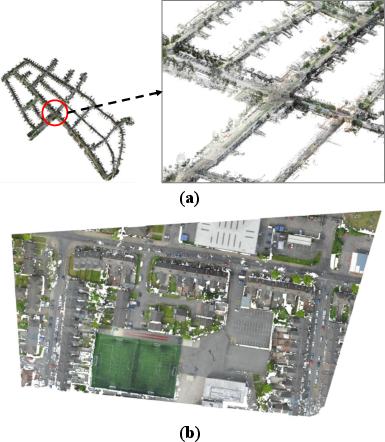
- CityLoc-K: car-mounted laser scans (LiDAR) in urban streets.
- CityLoc-C: drone-made 3D maps (photogrammetry) of cities.
- CityLoc covers bigger, messier areas—more like what people really describe.
Key terms in simple analogies:
- Point cloud: a 3D “dot painting” of the world.
- BEV image: a flat, top-down map like a drone photo.
- Scene graph: a structured list of “who’s in the scene” and “where they are.”
- Vision-LLM (VLM): an AI that connects pictures with words and can reason about both.
4) What did they find, and why is it important?
Main results:
- VLM-Loc beat previous best methods by a large margin on the new CityLoc benchmark.
- On CityLoc-K (street-level maps), it improved the success rate within 5 meters by about 14 percentage points over the previous top method (CMMLoc).
- It also generalized well to CityLoc-C (drone maps), where it again performed much better than older methods.
What mattered most:
- Directional words (like “left of,” “behind”) were crucial. Removing them cut accuracy almost in half.
- Combining both the BEV image (the top-down picture) and the scene graph (the structured list of objects) worked better than using either alone.
- The Partial Node Assignment step (matching only the clues that truly appear) greatly improved accuracy.
- Larger, stronger vision-LLMs helped even more.
Why it’s important:
- It shows that a language-aware, reasoning AI can locate places accurately in complex 3D maps using only text—a big step for real-world use where cameras or GPS may fail.
5) What does this mean for the future?
- Better pickups for robotaxis and delivery robots: If a rider says, “I’m by the big red store with the park to my right,” the robot could find them more reliably.
- More helpful urban assistants: City AR apps or service robots could understand human directions more naturally.
- Safer and more accessible navigation: Useful when GPS is weak or unavailable, or when sharing a photo isn’t possible.
- Research directions:
- Teach the AI to handle longer, multi-step instructions.
- Move from just “finding” to “acting,” combining localization with planning and navigation.
In short, VLM-Loc shows how to bridge human language and 3D city maps using a powerful vision-LLM, smart map representations, and a careful “only-match-what’s-real” strategy—leading to clearer reasoning and much better location guesses.
Knowledge Gaps
Knowledge gaps, limitations, and open questions
Below is a consolidated list of concrete gaps and unresolved questions that, if addressed, could substantially strengthen the work and guide future research.
- 3D information loss in BEV: Quantify how projecting to 2D BEV (and averaging per-object color) discards height, vertical topology, and occlusion cues; evaluate hybrids that keep lightweight 3D features (e.g., height maps, layered BEV, or voxel slices) and measure gains.
- Omitted scene-graph edges: The scene graph drops explicit edges and relational attributes; test adding learned relations (adjacency, distance bins, bearings, visibility/occlusion, road-topology constraints) and compare against the node-only design.
- Fixed heuristic thresholds in PNA: The partial node assignment relies on hand-tuned, class-dependent distance thresholds (5 m/15 m); study learnable or uncertainty-aware assignment (e.g., probabilistic matching, learned margins) and its sensitivity to map density/clutter.
- Ambiguity with repeated same-class objects: Analyze failure modes when multiple nearby nodes share the same class/color, and design disambiguation (e.g., multi-constraint matching with relative distances/angles between objects).
- Synthetic, templated language: Current queries are auto-generated from fixed templates (semantics, color, direction). Validate on human-authored, natural, noisy, or ambiguous descriptions (coreference, negation, synonyms, numerals, vague terms), and measure robustness to linguistic variability.
- Directional phrasing generality: Evaluate beyond cardinal/relative bearings (e.g., “behind the pharmacy,” “two blocks past the park,” “diagonally across”), including free-form phrasing, mixed frames of reference, and multi-step relational chains.
- Variable hint counts and noise: Performance is reported for a fixed number of hints (N_t = 6). Systematically study sensitivity to number, relevance, and contradiction of hints, and to missing/incorrect attributes (class, color, direction).
- Multilingual generalization: Assess cross-lingual performance (code-switching, non-Latin scripts) and whether instruction-tuned VLMs transfer localization ability across languages.
- 2-DoF assumption and planar ground: Extend from 2D coordinates to 3-DoF (add heading) or full 6-DoF localization; measure impact when the planar-ground assumption is violated (ramps, overpasses, hilly areas).
- City-scale localization pipeline: The method assumes a correct local map window; investigate scalable coarse-to-fine retrieval over city-scale maps and the interaction between retrieval errors and fine localization.
- Dependency on accurate semantics/instances: The pipeline presumes high-quality semantic labels and instance segmentation; quantify robustness to labeling noise, missing instances, category mismatches, and different taxonomy granularity across maps.
- Color dependence and sensor modality gaps: Many LiDAR maps lack reliable color; report performance without color cues and with intensity-only inputs; analyze modality transfer when colors are noisy or unavailable.
- Map resolution and spatial extent: Only one BEV resolution (224×224 over 50 m) is used; study trade-offs across map extent, pixel resolution, and performance/latency; characterize scale sensitivity and calibration to mixed-scale scenes.
- Robustness to map errors and change: Evaluate tolerance to map misregistration, temporal changes (construction, vegetation growth), and dynamic clutter; include experiments with deliberate perturbations and stale maps.
- Computational efficiency: Report end-to-end inference latency, memory footprint, and throughput on typical onboard hardware; profile the PNA and decoding stages and quantify the cost of larger VLMs.
- Uncertainty estimation and calibration: Add confidence measures for predicted positions and assignments; study whether uncertainty correlates with localization error and supports decision-making (e.g., fallback to clarification).
- Interpretability evaluation: Beyond correlating correct assignments with error, conduct human studies or standardized explainability metrics to assess if node assignments provide faithful, useful explanations.
- JSON parsing robustness: The approach depends on well-formed JSON outputs; measure failure rates and introduce constrained decoding or function-calling interfaces to harden parsing.
- Edge-case scenes: Benchmark difficult settings (dense downtown canyons, large open plazas, repetitive facades, uniform residential areas) and perform class/scene-type stratified analysis.
- Learned PNA vs. end-to-end grounding: Explore architectures that jointly learn correspondence and localization under a unified objective, including differentiable assignment or contrastive grounding tied to coordinate prediction.
- Active clarification: Test a loop where the model requests additional textual cues when assignment confidence is low; quantify how interactive refinement reduces error and how many turns are needed.
- Prompt and decoding strategies: Ablate the system prompt, chain-of-thought vs. direct decoding, constrained token vocabularies for coordinates, and their effect on accuracy and stability.
- Generalization beyond two sources: CityLoc spans KITTI-360 LiDAR and SensatUrban photogrammetry; extend to more cities, climates, seasons, sensor stacks (mono/stereo/radar-fused maps), and different urban morphologies.
- Open-world semantics: Evaluate zero-shot categories and long-tail classes not present in training taxonomies; study how unseen semantics in text affect grounding and localization.
- Failure mode taxonomy: Provide a detailed error breakdown (by distance bin, hint correctness, class types, node density, distance to boundary) to guide targeted method improvements.
Practical Applications
Below is an overview of practical, real-world applications enabled by the paper’s findings and methods (VLM-Loc, BEV + scene graph map representation, Partial Node Assignment, CityLoc benchmark). Items are grouped by time horizon and tagged with likely sectors. For each, we list indicative tools/workflows and the key assumptions/dependencies that affect feasibility.
Immediate Applications
- Curbside pickup localization for ride-hailing and robotaxi services (Mobility, Software, Robotics)
- What: Let riders describe surroundings (“I’m by the red mailbox opposite the pharmacy”) to pin precise pickup spots when GNSS is degraded.
- Tools/Workflows: “Describe your surroundings” mobile UI; Text-to-GeoPin API backed by VLM-Loc; HD-map tiling and scene-graph cache; JSON output with node matches + XY.
- Assumptions/Dependencies: Fresh point-cloud coverage of service areas; coarse region selection (GNSS/cell/route context) to choose the right submap; direction/color cues present in user text; privacy-safe handling of map data.
- Delivery/drop-off geofencing for logistics and couriers (Logistics, Last-mile)
- What: Convert customer descriptions into doorstep/gate geofences for accurate drop-offs and contactless deliveries.
- Tools/Workflows: Courier app plugin; dispatcher console widget; VLM-Loc inference service; audit trail of grounded nodes.
- Assumptions/Dependencies: Building/facade/entrance semantics in point clouds; frequent map refresh in construction-heavy neighborhoods.
- Event venue “find-me” assistants and safe meeting-point selection (Events, Public Safety)
- What: Attendees send short descriptions; system suggests verified gate/sector pins and safe rendezvous points.
- Tools/Workflows: Venue app chatbot; pre-event 3D scan to BEV/scene graph; crowd load-balancing logic around recommended pins.
- Assumptions/Dependencies: Up-to-date venue scans; seasonal layouts/fences modeled; multi-language support.
- Campus/building support desk localization (Education, Facilities Management)
- What: Students/visitors describe surroundings to localize incidents or service requests without photos.
- Tools/Workflows: ITSM plugin (e.g., ServiceNow) that attaches a GeoPin with matched scene-graph nodes; kiosk voice interface.
- Assumptions/Dependencies: Indoor/outdoor point-cloud coverage; mapped equipment/landmarks; on-prem deployment for privacy.
- AR wayfinding anchor placement from text (Software, AR/VR)
- What: Users describe visible landmarks; app places a consistent AR anchor and overlays a route.
- Tools/Workflows: ARKit/ARCore extension that calls VLM-Loc; anchor export to navigation stack; user prompt templates emphasizing direction terms.
- Assumptions/Dependencies: Device-to-map frame alignment; robust speech-to-text; map-AR coordinate calibration.
- Warehouse/factory robot dispatch from operator utterances (Robotics, Manufacturing)
- What: “End of Aisle 7, left of the pallet stacker” → robot receives an XY target without explicit coordinates.
- Tools/Workflows: ROS2 “LocalizeByDescription” node; prebuilt indoor scene graphs; fleet manager integration.
- Assumptions/Dependencies: Indoor LiDAR maps with aisle IDs and equipment classes; safety gates around target pins.
- Emergency call-taker assist for GNSS-denied callers (Public Safety, Telecom)
- What: Call-taker types paraphrased caller descriptions to get candidate pins near landmarks.
- Tools/Workflows: CAD plug-in; city LiDAR/photogrammetry maps compiled to BEV/scene graphs; confidence-ranked pins; auditable node matches.
- Assumptions/Dependencies: Inter-agency data-sharing; high-stakes QA and fallback SOPs; clear liability and accuracy thresholds.
- GIS/map QA and change-triage via text grounding (Geospatial)
- What: Analysts input textual checks (“bus stop opposite the stone arch”) to verify nodes and flag mismatches for change detection.
- Tools/Workflows: “Text-to-Node Grounder” in GIS; discrepancy dashboards; batch audits using synthetic queries.
- Assumptions/Dependencies: Semantically labeled scene graphs; tolerance for stale or occluded features.
- Museum/tourism self-guided assistance (Culture, Education)
- What: Visitors describe what they see to localize and receive contextual content or directions to nearby exhibits.
- Tools/Workflows: On-site app; precomputed indoor/outdoor scene graphs; multilingual prompt library.
- Assumptions/Dependencies: Venue scans; frequent exhibit reconfiguration handled via incremental map updates.
- Drone inspection landing/loiter point selection from operator text (Energy/Utilities, UAS)
- What: Operator describes visible structural references to pin safe loiter/landing sites in substations/campuses.
- Tools/Workflows: GCS plugin; aerial photogrammetry maps (CityLoc-C-like); preflight scene-graph tiles.
- Assumptions/Dependencies: High-quality aerial point clouds; obstacle updates; operations SOPs for final visual confirmation.
- Academic adoption of CityLoc benchmark and VLM-Loc code (Academia)
- What: Reproducible evaluation of text-to-point-cloud localization under larger, complex scenes.
- Tools/Workflows: CityLoc datasets (K/C); LoRA fine-tuning scripts; standardized Recall@K m metrics.
- Assumptions/Dependencies: GPU availability; licensing and redistribution constraints for map data.
- Daily-life meetups in complex outdoor spaces (Daily Life, Consumer Apps)
- What: “I’m next to the blue kiosk between two tree rows” → friend receives a precise pin without sharing photos.
- Tools/Workflows: Messaging app mini-APIs; privacy-first on-device or server-side inference.
- Assumptions/Dependencies: City map coverage; user consent and data governance.
Long-Term Applications
- City-scale, conversational localization and navigation (Smart Cities, Robotics)
- What: Multi-turn dialog localizes and navigates across dynamic, large areas; integrates planning and obstacle-aware routing.
- Tools/Workflows: Streaming map updates; dialog management; fusion with camera snapshots or audio cues.
- Assumptions/Dependencies: City-wide, frequently updated semantic point clouds; robust 6-DoF reasoning; dynamic-object handling.
- E911/E112 GNSS-free caller geolocation (Telecom, Public Safety)
- What: Standards-based “Text-to-Location” adjunct to Advanced Mobile Location for urban canyons or indoor callers.
- Tools/Workflows: Carrier gateway integration; CAD interoperability; confidence thresholds and human-in-the-loop verification.
- Assumptions/Dependencies: Regulatory approval; SLAs; multi-language robustness; bias/coverage audits.
- Universal accessibility assistants (Healthcare, Accessibility)
- What: Voice-only localization and guidance for blind/low-vision users in GNSS- or camera-constrained contexts.
- Tools/Workflows: On-device inference; haptic guidance; personalized spatial priors; multilingual NLU.
- Assumptions/Dependencies: Privacy-preserving on-device VLMs; reliable speech-to-text; fine-grained indoor maps.
- Fully voice-driven robot tasking in cluttered environments (Robotics, Logistics)
- What: “Meet me behind the cafe opposite the red sculpture, then pick up the box” → from description to plan and execution.
- Tools/Workflows: VLM-Loc fused with SLAM and task planners; semantic memory and world-model updates.
- Assumptions/Dependencies: Robust cross-modal grounding and 3D reasoning beyond 2-DoF; continual map updates.
- Retail/mall customer support via SMS chat (Retail, Customer Experience)
- What: Shoppers text brief descriptions to get precise store entrances or service-desk pins without an app.
- Tools/Workflows: Carrier/business messaging integration; map-graph services per property; queue management.
- Assumptions/Dependencies: Property-scale scans; tenancy churn handling; staff override workflows.
- Construction/AEC issue logging and progress tracking by description (Construction, AEC)
- What: Foremen describe a vantage/element to pin issues on as-builts without photos; link to BIM.
- Tools/Workflows: CDE/BIM connectors; periodic scans to maintain scene graphs; crosswalk between BIM IDs and nodes.
- Assumptions/Dependencies: As-built scans; stable BIM–scan alignment; site safety and connectivity.
- Mining/tunnel and industrial GNSS-denied operations (Energy, Mining, Heavy Industry)
- What: Workers localize and coordinate via short descriptions underground or in large plants.
- Tools/Workflows: Rugged edge devices; private on-prem inference; safety system integration.
- Assumptions/Dependencies: Harsh-environment mapping; very domain-specific semantics; latency constraints.
- Hospital indoor logistics and staff coordination (Healthcare)
- What: Staff describe local context to localize and dispatch AGVs or request support in complex wards.
- Tools/Workflows: EHR/RTLS integration; privacy-compliant, on-prem inference; fine-grained indoor semantics (wards, stations).
- Assumptions/Dependencies: Strict privacy and compliance; rapidly changing interiors; shift-time congestion dynamics.
- Platform products and developer ecosystem (Software, Tools)
- What: “VLM-Loc-as-a-Service,” BEV/SceneGraph compilers, synthetic query generators, and LoRA domain packs.
- Tools/Workflows: SDKs for mobile/ROS/GIS; CI for scene-graph builds; eval harness using CityLoc.
- Assumptions/Dependencies: Sustainable licensing; GPU/edge cost control; vendor-neutral schemas.
- Policy, standards, and governance (Policy, Standards)
- What: Data-sharing standards for semantic scene graphs; privacy-by-design guardrails; auditability of localization outputs.
- Tools/Workflows: Procurement templates for municipalities; red-team/bias evaluations; transparency reports with node-level rationale (via PNA).
- Assumptions/Dependencies: Cross-agency collaboration; privacy regulation alignment; public trust.
- Research extensions building on CityLoc and PNA (Academia)
- What: Benchmarks for multi-step spatial reasoning, 6-DoF text-to-pose, active agents combining localization with planning.
- Tools/Workflows: New datasets covering dynamic scenes; unified metrics beyond Recall@K m; ablations on language cues and scene complexity.
- Assumptions/Dependencies: Community contributions and shared protocols; reproducibility infrastructure.
Notes on global feasibility constraints across applications:
- Methodic assumptions: 2-DoF, locally planar ground surfaces; accuracy depends strongly on directional cues in text and availability of distinctive, semantically labeled objects.
- Data dependencies: High-quality, up-to-date, semantically labeled point-cloud maps (street- or aerial-level); color and instance segmentation improve grounding.
- System dependencies: Submap preselection (via coarse GNSS/cell or context); latency budgets; VLM licensing and on-device vs. server inference choices.
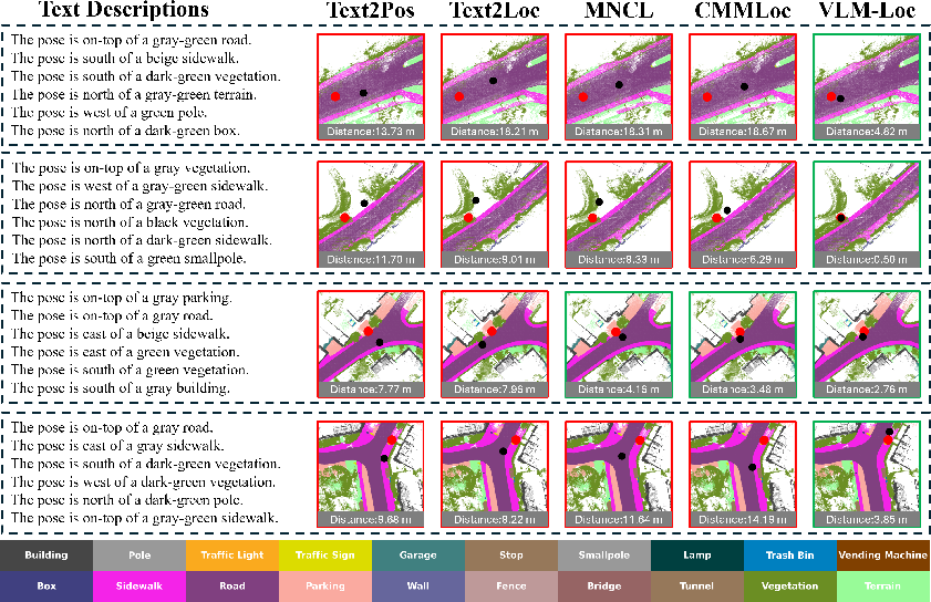
- Robustness: Domain gaps (indoor vs. outdoor, vehicle LiDAR vs. UAV photogrammetry) require adaptation; PNA reduces but doesn’t eliminate issues when described objects lie outside the current map.
- Privacy and safety: Handling of sensitive map content; explainability via node assignments (PNA) aids auditing and trust; human-in-the-loop for high-stakes uses.
Glossary
- 2-DoF (two degrees of freedom): A 2D position parameterization with x–y coordinates on the ground plane. "VLM-Loc estimates the 2-DoF position ξ in pixel coordinates."
- AdamW optimizer: An Adam variant with decoupled weight decay for more stable training. "We use the AdamW optimizer with a learning rate of 1×10⁻⁴ and a warm-up ratio of 0.05."
- Autoregressive decoding: Sequential generation where each output token conditions on previous ones. "We incorporate position prediction into the autoregressive decoding."
- BEV (bird's-eye-view) image: A top-down 2D rendering of a 3D scene used to align with image-trained VLMs. "we transform point clouds into bird's-eye-view (BEV) images"
- bfloat16 precision: A 16-bit floating-point format with wider exponent for efficient training. "All experiments are conducted in bfloat16 precision."
- Cauchy Mixture Model: A probabilistic model using Cauchy-distributed components for robust spatial modeling. "CMMLoc modeled 3D objects using Cauchy Mixture Model priors with integrated cardinal direction cues for fine localization."
- Cardinal direction cues: Discrete directional hints (e.g., north/south/east/west) used to constrain spatial reasoning. "Cauchy Mixture Model priors with integrated cardinal direction cues for fine localization."
- Cell-level retrieval: Retrieving candidate spatial cells before fine position regression. "Text2Pos formulates the problem as cell-level retrieval followed by position regression"
- CityLoc benchmark: A multi-source point-cloud dataset for fine-grained text-to-point-cloud localization. "we present CityLoc, a benchmark built from multi-source point clouds for fine-grained T2P localization."
- CLIP: A VLM pre-trained via image–text contrastive learning enabling zero-shot transfer. "Early works such as CLIP and ALIGN pioneered contrastive learning between image-text pairs"
- Coarse-to-fine strategy: A two-stage approach that first narrows the search space then refines estimates. "employed a coarse-to-fine strategy, retrieving candidate submaps before refining the position estimation."
- Contrastive learning: Training that pulls matched modalities together and pushes mismatched ones apart. "pioneered contrastive learning between image-text pairs"
- Cross-domain generalization: Robustness when transferring models between different data domains or sensors. "and is used to evaluate cross-domain generalization to unseen urban scenes with different sensing modalities and semantic distributions."
- Cross-modal representations: Joint embeddings that align information across text and visual/map modalities. "providing structured inputs for the VLM to learn cross-modal representations bridging linguistic and spatial semantics."
- DBSCAN: A density-based clustering algorithm for discovering instances in point clouds. "For “stuff’’ categories, points within each map are grouped into discrete instances using DBSCAN"
- GNSS (Global Navigation Satellite System): Satellite-based positioning used by vehicles for localization. "vehicles typically rely on the Global Navigation Satellite System (GNSS) for approximate passenger localization."
- Image-to-point-cloud (I2P) localization: Estimating pose by aligning image features to 3D map features. "Image-to-point-cloud (I2P) localization methods instead align image features with 3D representations"
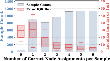
- Interquartile range (IQR): The spread between the 25th and 75th percentiles, summarizing error variability. "the interquartile range (IQR) illustrates the distribution of localization errors."
- LiDAR point cloud: 3D point data acquired via laser scanning, often from vehicles. "constructed from the LiDAR point cloud of KITTI-360"
- LoRA (Low-Rank Adaptation): Parameter-efficient fine-tuning by injecting low-rank adapters into layers. "LoRA-based parameter-efficient tuning"
- NetVLAD: A differentiable VLAD-based pooling layer for global descriptor learning. "combine PointNet with NetVLAD for global descriptor learning."
- Partial Node Assignment (PNA): A mechanism to align only the groundable textual objects to scene-graph nodes. "we introduce Partial Node Assignment (PNA) mechanism that explicitly supervises the VLM to associate textual cues with their corresponding spatial nodes"
- Photogrammetric point cloud: 3D reconstructions derived from multi-view images via photogrammetry. "the photogrammetric point cloud of CityRefer"
- Point-cloud-to-point-cloud (P2P) localization: Matching a query point cloud to a map point cloud for pose. "Pioneering point-cloud-to-point-cloud (P2P) localization methods"
- PointNet: A neural architecture that processes unordered point sets directly. "combine PointNet with NetVLAD for global descriptor learning."
- PointNetVLAD: A P2P localization model combining PointNet features with NetVLAD aggregation. "Pioneering point-cloud-to-point-cloud (P2P) localization methods, such as PointNetVLAD"
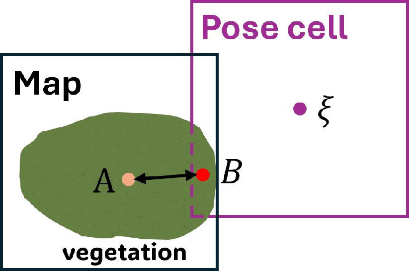
- Pose cell: A localized, visibility-defined region around a query pose used for generating text and supervision. "Each query location defines a pose cell"
- Qwen3-VL-8B-Instruct: A multimodal LLM backbone used for the proposed method’s fine-tuning. "We employ Qwen3-VL-8B-Instruct as the base model for the VLM-Loc framework."
- Recall@K m: Fraction of predictions within K meters of ground truth, used to evaluate localization. "we evaluate localization performance using Recall@K m"
- Rotation-equivariant architectures: Models whose outputs transform predictably under rotation, improving robustness. "enhance robustness through rotation-equivariant architectures in BEV representations."
- Scene graph: A structured representation with nodes for objects and (implicit) relations, supporting reasoning. "a scene graph is simultaneously constructed to capture higher-level semantic relations among objects."
- Stuff and object categories: Semantic segmentation taxonomy separating amorphous “stuff” from countable “objects.” "When a pixel contains both
stuff'' andobject'' categories, the ``object'' category is rendered with higher priority" - UAV (Unmanned Aerial Vehicle): Aerial platform (drone) used to capture photogrammetric point clouds. "unmanned aerial vehicle (UAV)–based photogrammetric point clouds"
- Vision-LLM (VLM): A multimodal model jointly processing visual inputs and language for reasoning. "Vision-LLMs (VLMs) offer a promising foundation for this goal."
Collections
Sign up for free to add this paper to one or more collections.