- The paper introduces a novel reverse-martingale regularization for RNNs that improves hidden state stability and enables early detection of drought onset.
- The method integrates a backward-coherence loss with standard forecast loss, achieving a 43–55% reduction in hidden-state path instability without sacrificing next-day forecast skill.
- Empirical evaluations across diverse hydroclimates and synthetic tests demonstrate significant early-warning leads for slow-onset droughts, highlighting actionable improvements in risk detection.
Reverse-Martingale Regularized Recurrent Neural Networks for Coupled Precipitation Forecasting and Early Warning
Introduction
The intersection of precipitation forecasting and actionable early warning remains a critical challenge in hydrometeorology, particularly for drought detection. While operational systems typically treat forecasting and warning as decoupled, this work proposes a formal coupling via a regularization strategy—a reverse-martingale (RM) penalty—applied to recurrent neural networks' (RNNs) hidden states. This approach aims to preserve operational forecast skill while transforming the model’s internal representation into a stable risk-detection statistic. The method is systematically evaluated on station-scale precipitation records from diverse hydroclimates—monsoonal Taiwan, semi-arid Texas, temperate Germany, and Mediterranean Anatolia—plus controlled synthetic data.
Methodology: Reverse-Martingale Hidden-State Regularization
A recurrent neural network is trained to predict accumulated precipitation using local meteorological observations. The key innovation is an additional backward-coherence loss, the reverse-martingale penalty, which encourages the hidden state ht to be back-projectable from its successor via a learned function gϕ: the penalty term is LRM=T−11t=1∑T−1∥ht−gϕ(ht+1)∥2. This regularizer steers the hidden trajectory to remain smooth during ordinary evolution, making abrupt meteorological transitions detectable as significant residuals. The joint objective combines the task-specific forecast loss (CRPS on probabilistic precipitation) with the RM penalty, annealed on a time schedule to protect early-stage forecast learning.
Hidden-state defects dt=ht−1−gϕ(ht) are computed online post-assimilation and standardized over pre-event climatology. A one-sided CUSUM detector monitors the standardized defect; regime-specific sign conventions are used (monitor downward shifts for drought). The detector threshold is empirically calibrated to a target average run length (ARL0) for false alarms using Monte Carlo simulation on a held-out null set.
A critical property of the RMRNN is forecast-skill preservation. On all real-world station datasets across four contrasting regions, RM regularization reduces hidden-state path instability Qpath by $43$–55% relative to the GRU baseline or the same architecture with the penalty disabled (λ=0), without measurable loss in next-day forecast accuracy (skill differences <0.5% MSE). Next-day heavy-rain warning skill (AUC for local 95th percentile) is statistically indistinguishable between RMRNN and GRU.
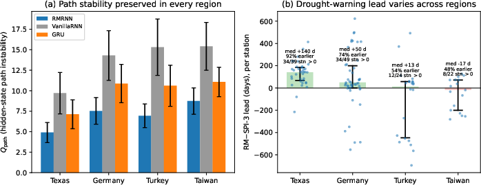
Figure 1: Hidden-state path instability gϕ0 is sharply reduced by RMRNN relative to unregularized networks across all climate regions.
Early Drought Warning: RM Defect vs. Precipitation Index
The principal empirical claim concerns early warning: the RM defect, monitored via a sequential CUSUM detector, is benchmarked against the SPI-3 accumulation index. The advance warning (lead) provided by the RM-detector varies by region, ranging from a median of gϕ1 days (4.5 months) in semi-arid Texas (earlier in 92% of runs and 34/39 stations) to gϕ2 days in Germany, and is substantially smaller in Turkey and statistically null in Taiwan overall. However, in Taiwan, the warning advantage is localized—a median lead of up to gϕ3 days appears in steep headwater catchments, while the wet windward coast shows a lag.
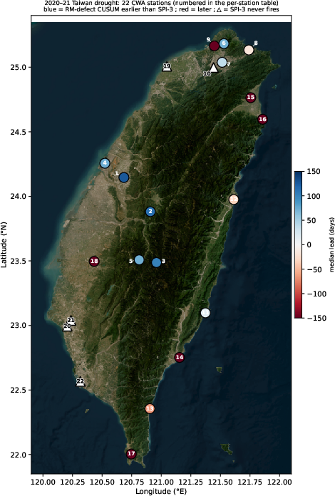
Figure 2: Per-station early-warning lead of the RM-defect CUSUM over the SPI-3 CUSUM for the 2020–2021 Taiwan drought. The RM detector leads in central catchments but lags the SPI-3 on the wet monsoon coast.
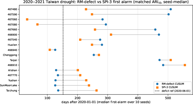
Figure 3: First-alarm day for RM-defect CUSUM (circles) and SPI-3 CUSUM (squares) on the real 2020--2021 Taiwan drought, per station. Leads are terrain-dependent, with the RM alarm preceding SPI-3 in key headwaters.
This terrain and hydroclimate dependence suggests that the method provides early warning when drought onset manifests as a multivariate regime shift that precedes the rainfall deficit detectable by SPI-3. Where the deficit and onset coincide (e.g., Taiwan’s monsoon coast), accumulation-based indices are as timely, and the RM advantage disappears.
Controlled Synthetic Study: Mechanism and Limitation
A synthetic testbed with known onset times verifies and explains these findings. Under injected drought, the RM defect CUSUM detects 92% of onsets at a mean lead of 57 days over SPI-3 for the same ARLgϕ4, with a slightly elevated false-alarm rate—reflecting an explicit trade-off of (calibrated) false alarms for earlier detection. For heavy-rain onsets (sharp regime changes), the RM defect adds no lead relative to direct monitoring of precipitation—detection is near-optimal with standard metrics, and the defect’s utility is exclusive to slow-onset anomalies.
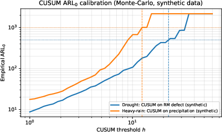
Figure 4: Monte-Carlo CUSUM ARLgϕ5 calibration curve ensures empirical comparability across detectors by matching false-alarm rates.
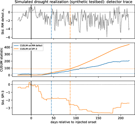
Figure 5: Simulated drought realization: The RM-defect alarm (blue) precedes SPI-3 (orange) by significant lead; onset is at day 0.
Comparison with Other Deep Models and Practical Implications
RMRNN is competitive in forecast skill with heavier gridded spatial sequence models (ConvLSTM, PredRNN, U-Net), trailing by less than 2.5% on synthetic grid testbeds, but without exceeding their performance. The method’s value is thus not in higher forecast skill but in adding a diagnostic signal—an interpretable, stable warning residual—at no forecast cost.
The RM framework is architecture-neutral, operates with multi-variable (e.g., combined precipitation-soil-moisture-temperature-wind) inputs, and maintains calibration across input dimensionalities. The computational overhead is minimal (one additional MLP per time step and no change to inference hardware requirements).
Empirically, regularizing backward coherence yields a hidden state whose residuals possess a climatologically stable right-skewed null, enabling reliable calibration of sequential change detectors—contrasting with unregularized RNN/LSTM residuals that are prone to drift.
Limitations and Future Directions
Several open issues remain. The correlation between hydroclimate/terrain and warning lead is observed but not causally established—wider multi-basin, multi-event studies are necessary. Alternative spatial neighborhood definitions (flow-path versus Euclidean), streaming online calibration, and extension to sub-daily flash-flood scenarios are outlined but not implemented. Integration with operational numerical weather prediction residuals, regression of early warning lead against climate covariates, and adaptation of backward coherence regularization to more complex sequence models (attention, graph, state space) are tangible next steps.
Conclusion
Reverse-martingale regularization transforms a standard recurrent precipitation forecasting model into a joint forecasting–and–early-warning system. Forecast skill is rigorously preserved while hidden-state path stability is markedly enhanced. The standardized reconstruction defect, monitored with a sequential detector, provides a calibrated early-warning signal—yielding substantial practical advantage for drought risk when hydroclimatic conditions permit, and demonstrably no disadvantage otherwise.
The warning benefit is strongly context-dependent—marked where drought onset is delayed relative to rainfall deficit (e.g., Texas, high-relief Taiwan catchments), and absent where deficit and onset are synchronous. This conditionality is a crucial methodological insight. The operational implication is clear: the method is conservative (never worse on forecast skill), provides robust model interpretability, and supplies actionable early warning when physically plausible.
The approach generalizes beyond precipitation, with potential in other regime-shift detection domains using RNNs or transformer-based models. Determining the climatological predictors of early-warning lead, formal integration with numerical weather prediction, and systematic quantification of the hydroclimatic dependence of early warning are essential avenues for future research.