- The paper presents an interpretable procedural program for 3D shape synthesis that enables precise and controllable shape manipulation.
- It employs a directed acyclic graph to integrate continuous, discrete, and binary parameters, ensuring coherent structural adjustments.
- Experimental results show superior performance over existing methods using Chamfer Distance, confirming its robustness and generalizability.
GeoCode: Interpretable Shape Programs
Introduction
The paper "GeoCode: Interpretable Shape Programs" (2212.11715) introduces a novel approach to the problem of 3D shape synthesis, focusing on creating an interpretable and editable parameter space that facilitates intuitive shape manipulation. The key challenge addressed by GeoCode is the dual requirement of modeling both continuous and discrete variations in 3D shapes, transcending the limitations of current methods which either lack intuitive interpretability or produce coarse geometric outputs. GeoCode capitalizes on a procedural methodology, effectively combining complex rules to enable high-level edits that seamlessly translate into refined, high-quality 3D shapes. This system bridges the gap between abstract parameter spaces and tangible geometric outputs, making it feasible to perform controlled local and global shape modifications.
Methodology
GeoCode employs a procedural program constructed as a directed acyclic graph (DAG), where nodes represent operations ranging from basic mathematical functions to mesh transformations. This setup allows for modularity and flexibility in defining shape components and their interrelations. Human-interpretable parameters are used to control the attributes of these nodes, enabling direct manipulation of geometry through discrete, binary, and continuous inputs.
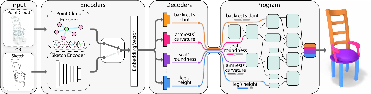
Figure 1: System overview. GeoCode learns to map a point cloud or a sketch input to an intuitively editable parameter space. The input passes through the corresponding encoder to obtain an embedding vector which is then fed to a set of decoders that predict the interpretable parameters. The program enforces a set of rules that, given a parameter representation, produces a high-quality shape by construction.
The program uniquely supports structural interactions and alterations, ensuring that changes in one component are coherently propagated through the model, maintaining structural integrity and semantic consistency. For instance, altering the roundness of a chair's seat autonomously adjusts other vertices to preserve overall coherence.
Experimental Results
The effectiveness of GeoCode is validated through extensive experiments demonstrating its capabilities in accurate shape recovery and generalization, even with out-of-distribution datasets. The shapes generated by GeoCode maintain structural validity across various tests, outperforming existing techniques such as StructureNet and ShapeAssembly in both quantitative and qualitative assessments. A notable aspect of the paper is the use of Chamfer Distance as a metric to benchmark shape reconstruction accuracy, indicating that GeoCode achieves superior performance in preserving the fidelity of reconstructed shapes.
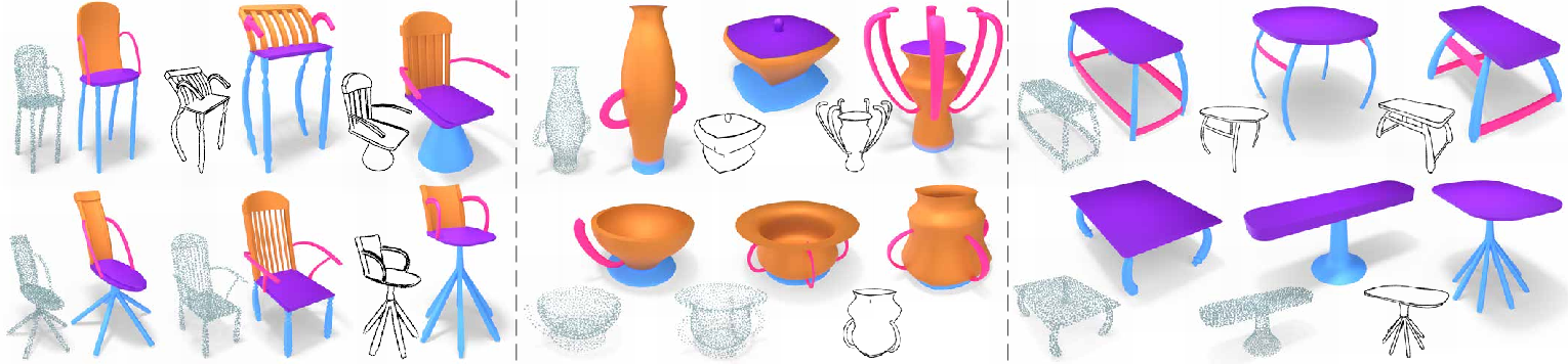
Figure 2: Shape gallery. Showing reconstructed shapes on our test set. Our procedural program produces high-quality geometry from a 3D point cloud or a 2D sketch and contains consistent part segmentation information across the resulting shapes.
Implications and Future Directions
GeoCode's ability to generalize and maintain robustness to various perturbations in input data—such as noise in point clouds or variability in sketch styles—highlights its potential utility in real-world applications, particularly in computer graphics and virtual reality. The system's inherent interpretability and flexibility open avenues for further exploration in more complex scenarios, including 3D scene representation and interactive shape design.
The authors propose future enhancements that could incorporate additional attributes like UV texture maps and material properties, thus enriching the procedural model's versatility and applicability in broader contexts. Given the promising results demonstrated, GeoCode sets a foundational precedent for the integration of interpretable geometry manipulation within traditional 3D modeling workflows.
Conclusion
GeoCode represents a significant advancement in the field of 3D shape synthesis, providing a sophisticated yet accessible means of shape manipulation through an interpretable parameter space. This methodological breakthrough paves the way for enhanced user interaction with 3D models, offering precise control over shape characteristics and ensuring stable and coherent geometric outputs. By establishing a robust framework for interpretable shape processing, GeoCode holds substantial potential for practical deployment across various disciplines requiring detailed and customizable shape creation.