- The paper presents Diff-Flood, a novel approach that uses denoising diffusion probabilistic models to forecast coastal flood levels.
- It integrates spatial features, such as digital elevation data, and temporal covariates using CNNs and a UNet-based attention framework to enhance prediction accuracy.
- Ablation studies show that combining historical data with spatial and temporal inputs improves performance by up to 47%, ensuring scalability and robustness.
Denoising Diffusion Probabilistic Models for Coastal Inundation Forecasting
Introduction
Coastal flooding is a growing concern, especially along vulnerable geographic areas such as the U.S. East Coast. This paper addresses the challenge with "Diff-Flood," a novel probabilistic forecasting method tailored for spatiotemporal inundation prediction using denoising diffusion probabilistic models. The methodology leverages both spatial features such as digital elevation data and temporal covariates, alongside historical inundation data, to forecast flood levels more precisely than existing hydro-dynamical or deep learning approaches. Such forecasting is vital for both policy-making and real-time response strategies, given the demands for accurate, scalable, and real-time analysis.
Hydrodynamic models such as SOBEK and SCHISM, while detailed, are computationally intensive and unsuitable for real-time predictions. Various deep learning models like LSTMs and CNNs have been considered as surrogates, but they often fail to incorporate or scale with spatial dependency effectively. Diffusion models, originally for image generation, have seen recent adaptations like TimeGrad and DiffSTG for temporal data yet face challenges when scaling for high-resolution spatiotemporal tasks.
Methodology
Diff-Flood operates by formulating coastal inundation forecasting as a spatiotemporal problem where the model learns both spatial and temporal dynamics. The inundation level predictions account for both the elevation matrix as spatial context and time-series co-variates as temporal context. The architecture utilizes convolutional neural networks to process spatial dependencies and cross-attention mechanisms within a UNet framework for temporal dependencies. The underlying denoising diffusion model captures the probabilistic nature of forecasting (Figure 1).
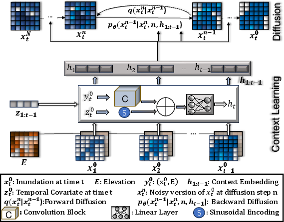
Figure 1: Architecture of proposed Diff-Flood Model.
Implementation and Experiments
The Diff-Flood model was trained on the Eastern Shore of Virginia data spanning over 89 days, demonstrating improvements in Normalized Root Mean Square Error (NRMSE) and Normalized Average Continuous Ranked Probability Score (NACRPS) by 6% to 64% against various baselines such as DiffSTG and LSTNet. Extensive experiments were performed across multiple patch sizes and configurations, ensuring both scalability and robustness. A noteworthy result is Diff-Flood's ability to handle high-dimensional datasets better than other state-of-the-art models, which often fail at large scales (Figure 2).
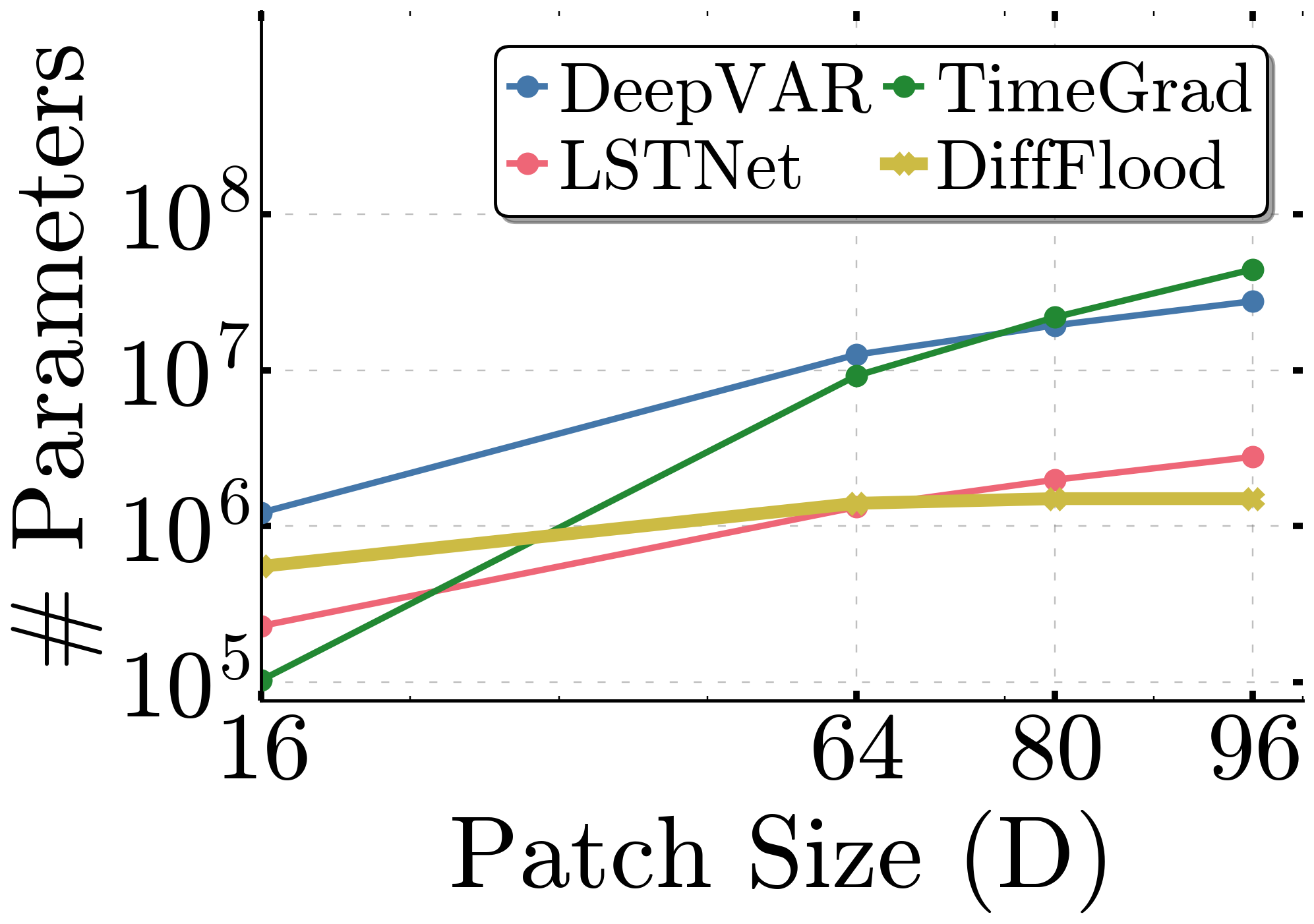
Figure 2: Scaling in Model Parameters (Log scale in Y axis) with increasing patch configuration.
Ablation Studies
The model's design includes a thorough investigation into its components' contribution. The ablation study highlights the effectiveness of incorporating both elevation data and temporal covariates. Models employing both components exhibit up to 47% better performance than those that utilize historical data without these augmentations (Figure 3).
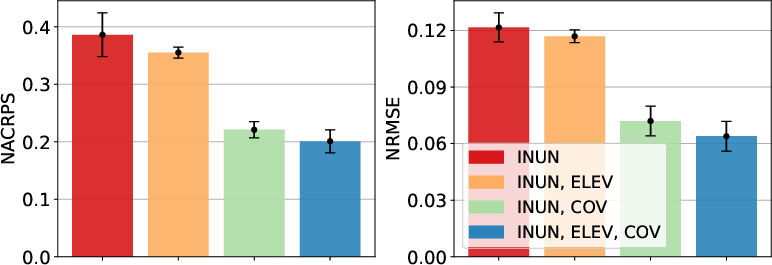
Figure 3: Bar-plots showing performance comparison of the four configurations of Diff-Flood on our test dataset of configuration 64x64x10.
Application and Future Work
Diff-Flood facilitates complex inundation scenario queries pertinent to policymaking. For example, determining the probability of certain areas flooding within specified times can inform evacuation planning and resource allocation (Figure 4). While it currently focuses on coastal flooding, the methodology is adaptable to various spatiotemporal forecasting domains, potentially expanding its utility to areas like traffic flow prediction and environmental monitoring.
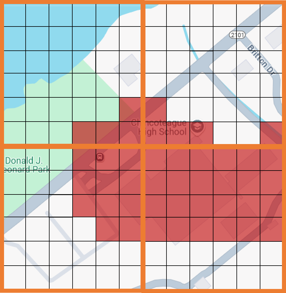
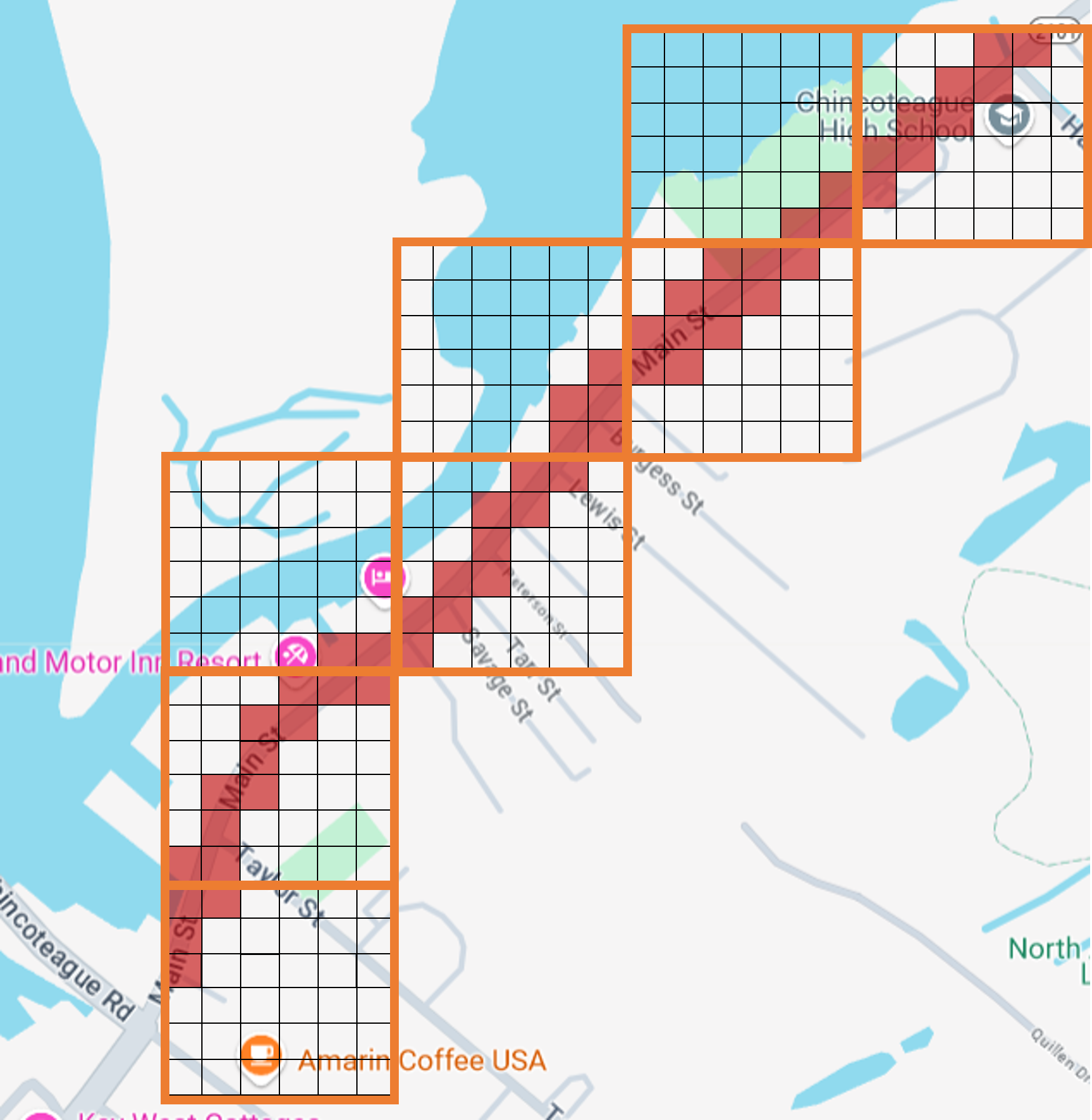
Figure 4: Potential queries addressing risk in a school area and routes in Eastern Shore of Virginia.
Conclusion
Diff-Flood sets a new benchmark in coastal inundation forecasting by integrating advanced probabilistic models with spatial and temporal dynamics. The method not only surpasses existing practices in accuracy and scalability but also paves the way for enhanced data-driven decision-making in coastal management. Further iterations could explore its applicability across other environmental and logistic fields, optimizing real-time prediction capabilities, particularly in urban planning and smart city infrastructures.