- The paper establishes an empirical framework integrating multimodal public transport with walking, quantifying amenity access through combined transit and walking catchments.
- It introduces a novel ellipticity metric to capture geometric asymmetry, revealing how corridor-shaped accessible areas influence spatial equity in urban peripheries.
- Regression analysis shows that multimodal connectivity enhances social mixing, though benefits vary with neighborhood socio-economic conditions and urban topology.
Public Transport Integration and Accessibility in the 15-Minute City: An Empirical Framework
Conceptual Context and Motivation
The 15-minute city paradigm has garnered broad attention as a post-pandemic urban model emphasizing localized access to amenities via active mobility, aiming to reduce car dependence and enhance social inclusivity. However, realization challenges exist, especially in peripheral urban zones with amenity scarcity and socio-economic segregation. The paper "Public transport in the 15-minute city" (2604.00699) addresses the underexplored aspect of public transport’s role in augmenting short-range accessibility and social mixing under this model. By empirically analyzing Helsinki, Madrid, and Budapest, the paper establishes a technical framework for integrating multimodal mobility—walking plus public transport—into accessibility analyses, quantifying its impact on amenity access and social integration.
Methodological Advances: Multimodal Accessibility Network Construction
The study constructs multilayer networks using GTFS timetables, clustering public transport stops into mobility hubs to model realistic transfers. Network edges represent transit lines weighted by average travel times, incorporating a transit penalty to account for transfer times. The accessible area from each hub is defined via a union of 10-minute transit plus 5-minute walking catchments and compared against traditional 15-minute walking radii. Amenity and socio-economic access are quantified by aggregating OpenStreetMap POI categories and fine-scale income, real estate, and Gini coefficient data, tailored to each city’s data availability.
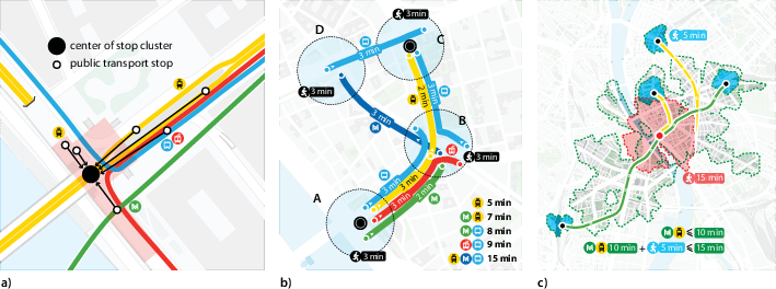
Figure 1: Schematic for construction of accessibility networks from GTFS data, illustrating clustering, network edge formation, and multimodal catchment modeling.
Topological Characterization: Ellipticity and Urban Geometry
A novel metric, ellipticity (Ep), is introduced to capture the geometric asymmetry of multimodal accessible areas—ranging from circular (evenly distributed) to elliptical (corridor-shaped) forms. The spatial structure is key, as peripheral hubs display higher Ep, indicating accessibility corridors typically aligned toward central areas.
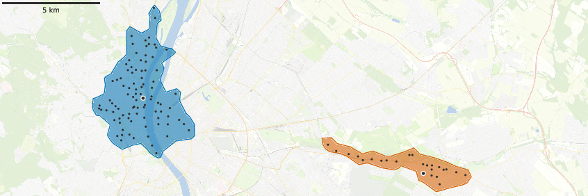
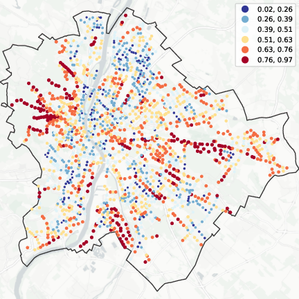
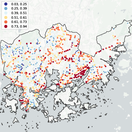
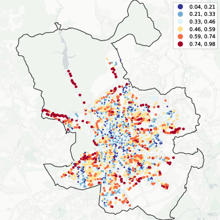
Figure 2: Examples of round and elliptic multimodal accessibility polygons; spatial distribution of high ellipticity in peripheries for Budapest, Helsinki, and Madrid supports corridor-type access.
A statistical analysis reveals that peripheral neighborhoods consistently exhibit elevated Ep values, independent of city-specific context, suggesting structural constraints imposed by radial public transport lines.
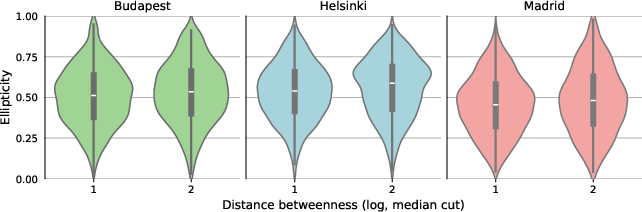
Figure 3: Peripheral neighborhoods in all three cities exhibit higher mean ellipticity, but with substantial spread, indicating heterogeneity in multimodal access morphology.
Empirical Findings: Amenity Access via Multimodal Mobility
Regression analyses demonstrate that allowing 10 minutes of public transport substantially increases the diversity of available amenity types beyond walking-only catchments. This multimodal premium scales with the additional area covered (Sp), but spatial shape (ellipticity) and location relative to the urban center modulate the gains. Amenity-access improvement is robust, but in Budapest, disadvantaged areas with highly elliptical reach do not obtain as many new amenity types, evidencing spatial inequity in corridor access.
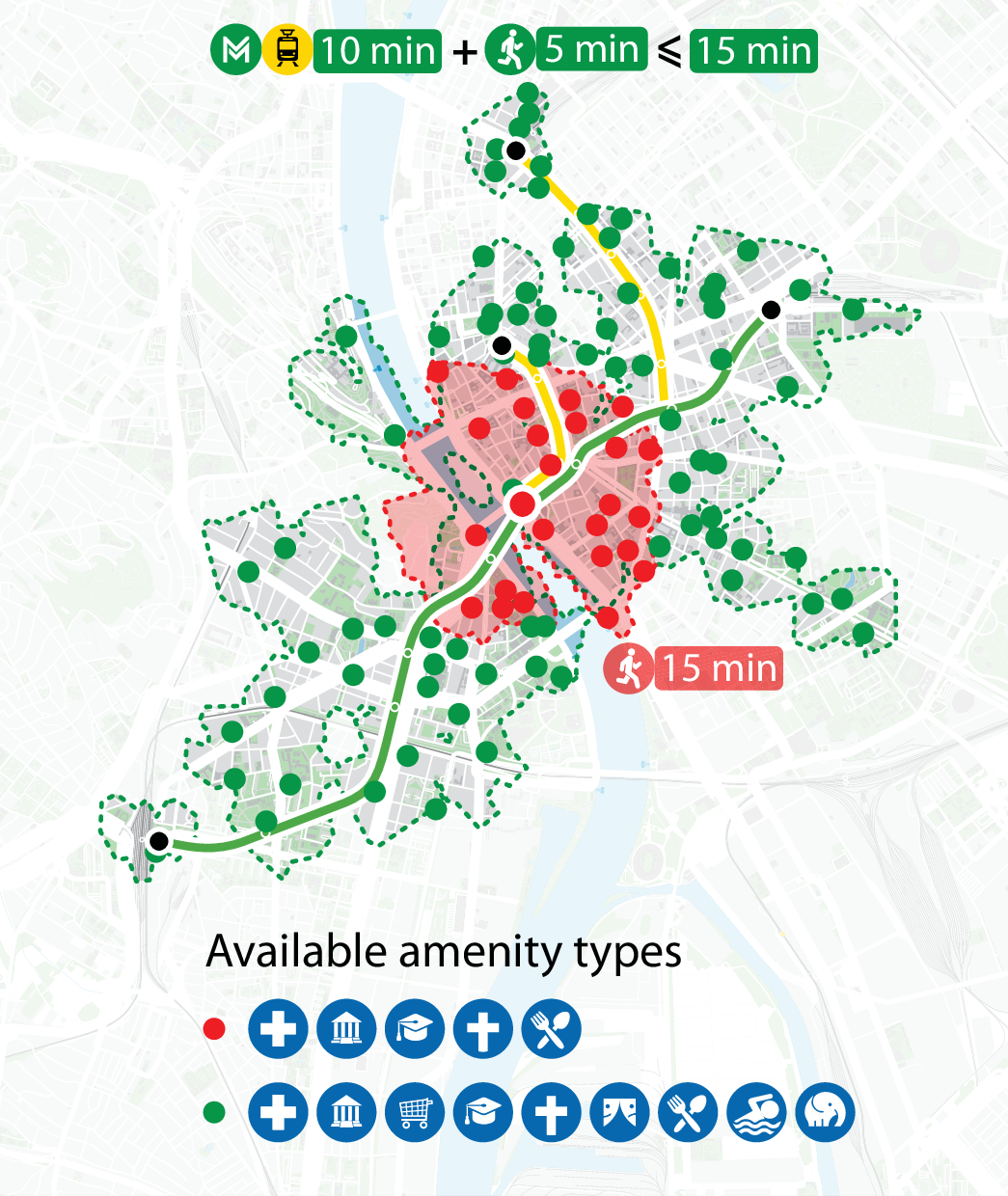
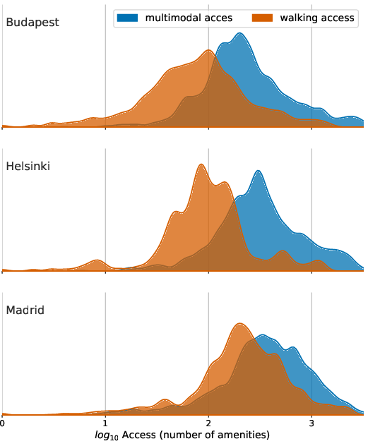
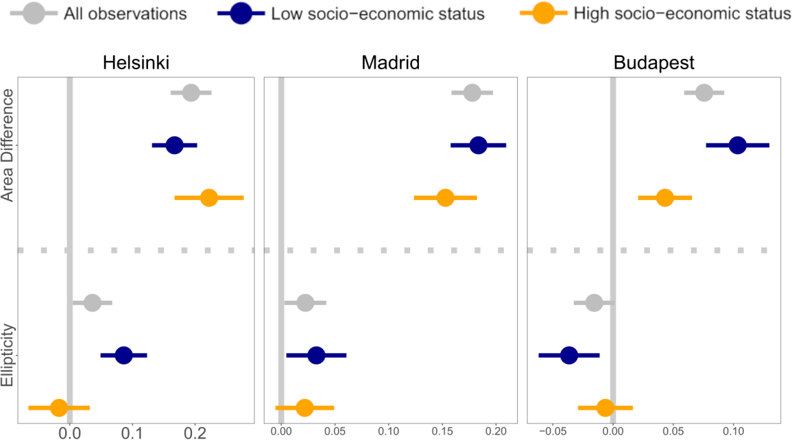
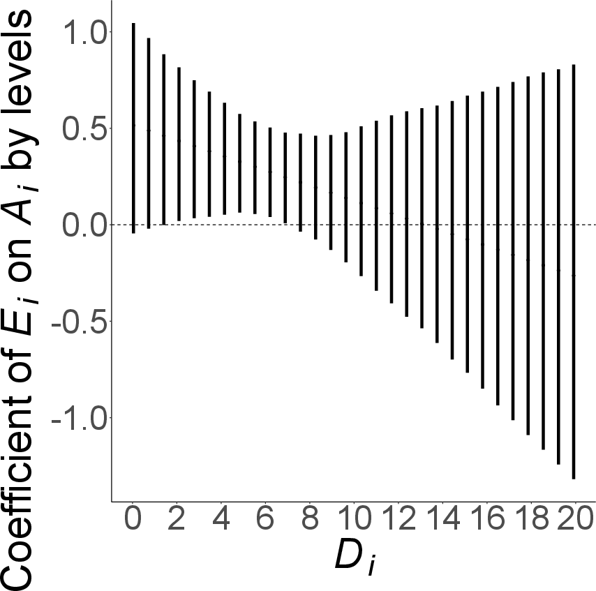
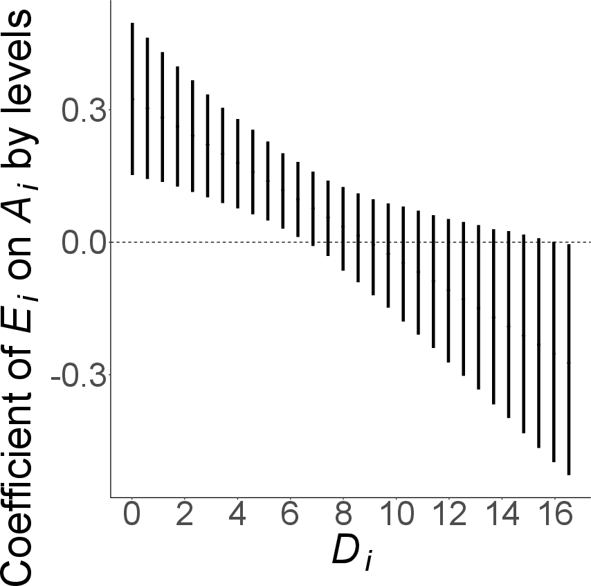
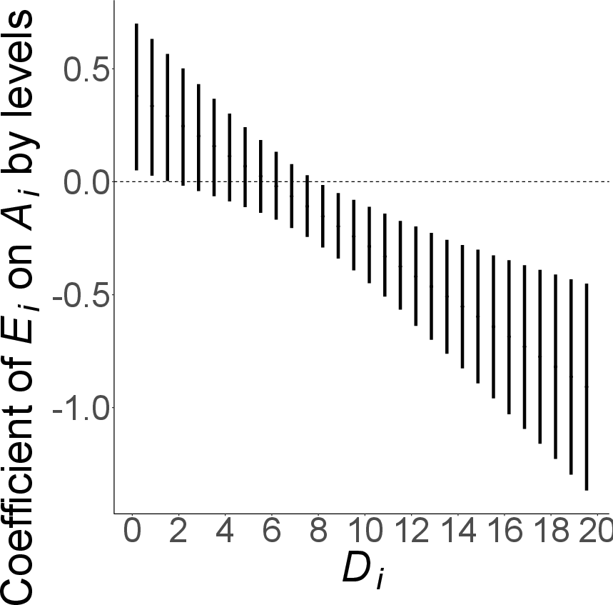
Figure 4: Quantification and regression analysis of amenity access gains via multimodal mobility; breakdown by socio-economic status and marginal effect of ellipticity versus distance from city center.
Marginal effects illustrate a monotonic decrease in the amenity-access benefit of ellipticity with increasing distance from the urban core; in peripheries, radial connections do not compensate for amenity deficits.
Socio-Economic Mixing: Limits and Gradients
The Gini index is utilized to evaluate social mixing potential within catchments. Multimodal mobility induces a slight shift toward higher socio-economic diversity, but the magnitude is limited, reflecting that even expanded catchments often encompass similarly segregated areas. The effectiveness of corridor-type (elliptical) access for enhancing social mixing is context-dependent: in Helsinki and Madrid, high-status neighborhoods benefit most, while Budapest exhibits a stronger effect in lower-status locations.
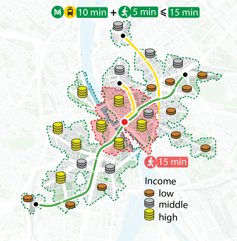
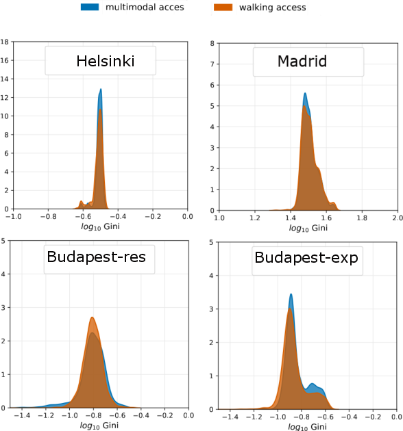
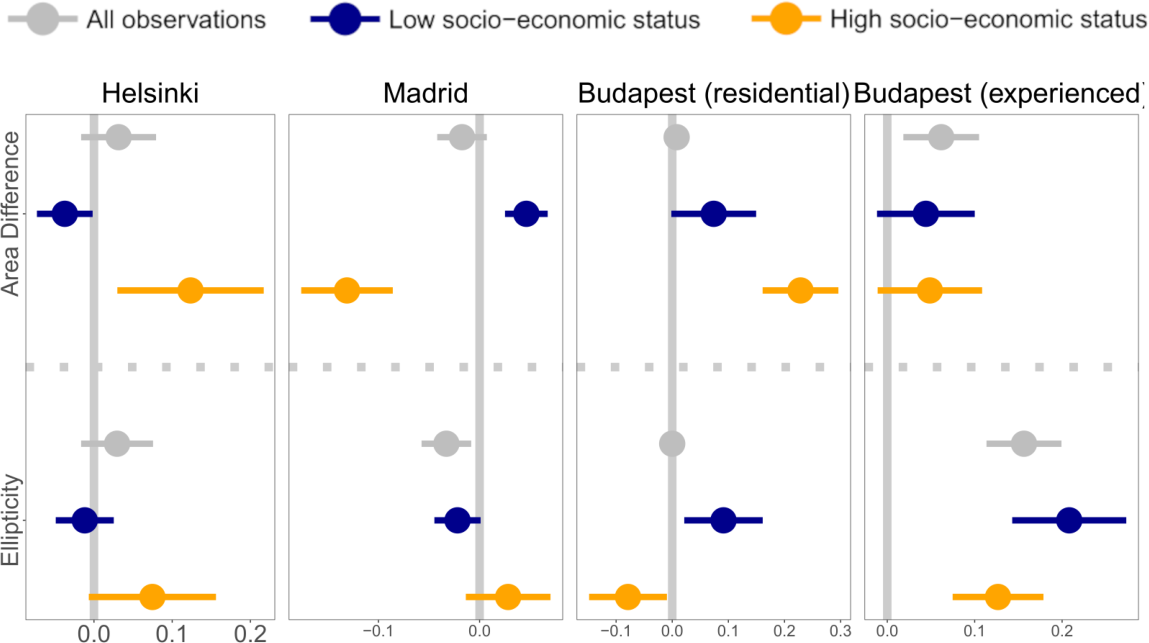
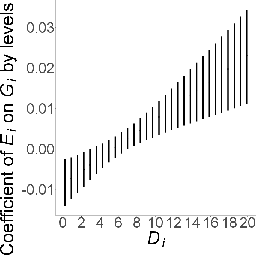
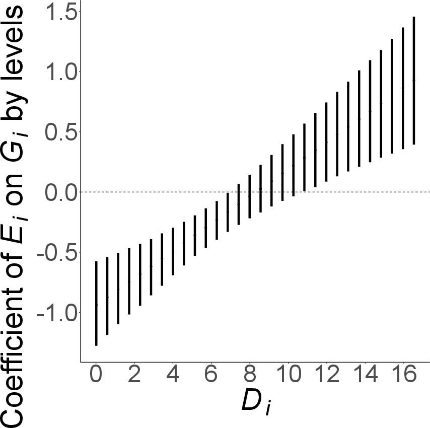
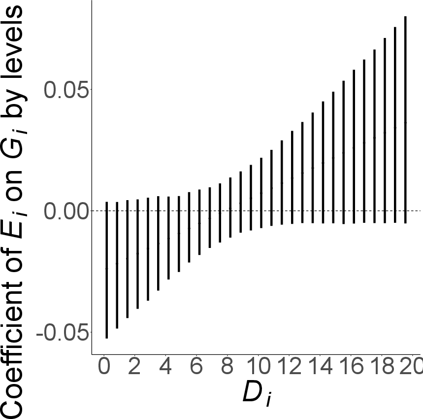
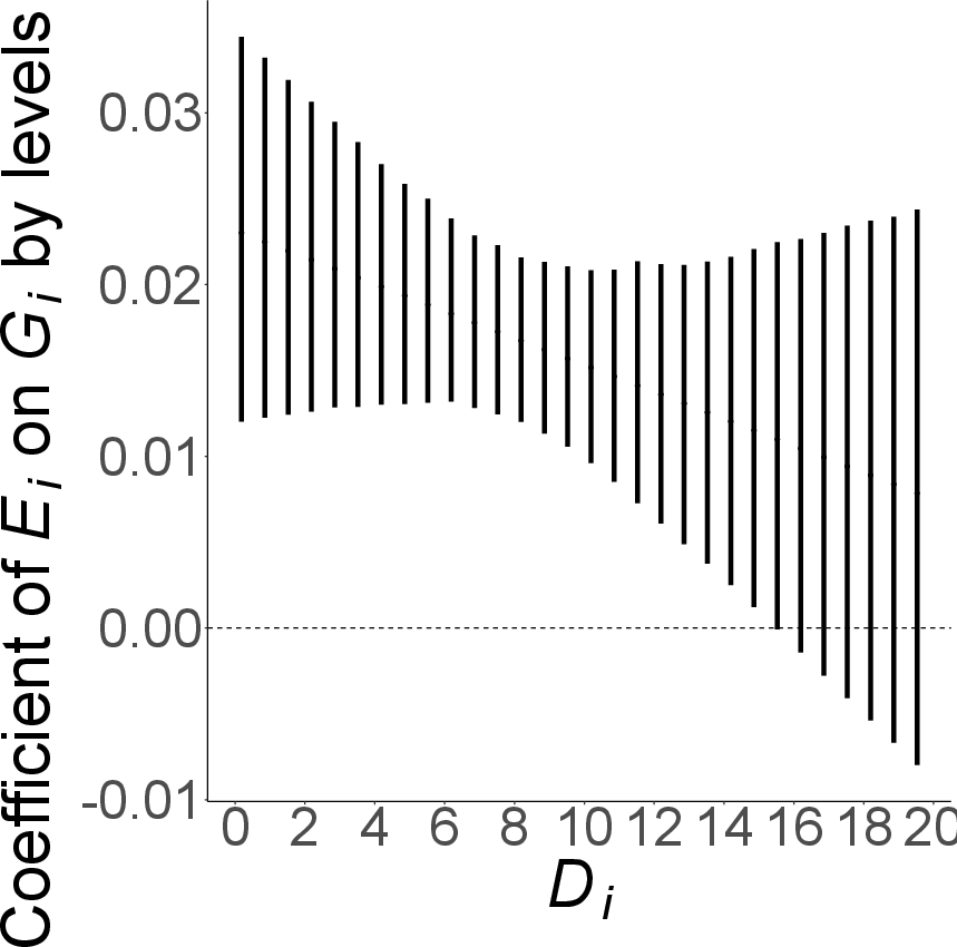
Figure 5: Analysis of socio-economic mixing potential via Gini index, showing moderate improvements and differentiated effects of multimodal mobility by neighborhood status and location.
Notably, the marginal effect of ellipticity on residential social mixing increases with distance from the city center, supporting the hypothesis that radial corridors—while suboptimal for amenity access—are better suited for bridging socio-economic divides in peripheries.
Practical and Theoretical Implications
The findings emphasize that public transport must be conceptualized as an intrinsic component of 15-minute city accessibility, not merely compensatory for poor walkability. Spatial geometry and network topology are critical determinants: corridor-dominated expansions generated by radial lines are effective for enhancing social mixing but inefficient in increasing amenity diversity in peripheries. This points toward the necessity for polycentric network design, connecting peripheral areas both radially and horizontally, thereby supplementing active mobility and mitigating monocentric biases. City-specific geography (e.g., Helsinki’s coastal constraints) further shapes outcomes and should inform network optimization.
Limitations and Directions for Future Research
The study relies on scheduled GTFS data, omitting dynamic congestion, service reliability, and real-world waiting times. Socio-economic mixing measures are heterogeneously defined across cities, and the 15-minute threshold is normative. Future work should integrate real mobility traces, enrich amenity typologies, model dynamic transport service frequencies, and extend the framework to diverse urban contexts, including emerging urban morphologies and multimodal shared mobility. Longitudinal analyses linking accessibility premiums to repeated social interactions and segregation reduction are especially pertinent.
Conclusion
This paper advances the empirical study of the 15-minute city paradigm by embedding public transport into accessibility modeling. Multimodal mobility enhances amenity access and social mixing, but its spatial geometry and network topology orchestrate heterogeneous and sometimes contradictory outcomes. Optimizing urban liveability and inclusivity demands polycentric transport networks, spatially tailored to complement active mobility, especially in peripheral zones. The methodological framework provides a foundation for evaluating equity and functional impact of multimodal interventions, with implications for sustainable urban planning and future urban mobility systems.

