- The paper presents a dual-pathway model that separately processes semantic and geometric features for robust multi-view spatial reasoning.
- It employs geometry-aware 3D reconstruction and dynamic graph-based alignment to overcome occlusion and perspective distortions in urban environments.
- Empirical results show significant improvements in spatial reasoning metrics, highlighting the method’s benefits for UAV mission planning and autonomous navigation.
UAV-Satellite Collaborative Spatial Reasoning: The SatAgent Framework
Motivation and Limitations of Existing Approaches
Autonomous spatial reasoning in urban aerial environments is a central requirement for embodied UAV intelligence. Conventional vision-LLMs (VLMs) and spatial reasoning systems that operate solely from the UAV perspective are hampered by two central limitations: (1) the inherent occlusion, distortion, and incomplete context of a single, oblique viewpoint; (2) the lack of explicit geometric modeling, with most models relying on weak semantic correlations that degrade under perspective or scale changes. These deficiencies are summarized in (Figure 1).
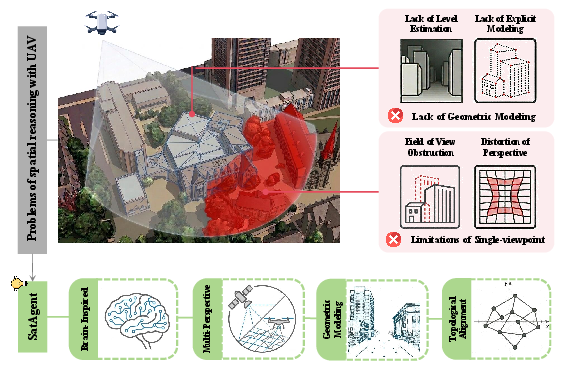
Figure 1: Two principal limitations of mainstream UAV spatial reasoning: limitations of single-perspective perception and insufficient spatial geometric structure modeling.
Drawing inspiration from the human dual visual pathway theory—which posits distinct but synergistic ventral (semantic) and dorsal (geometric/spatial) streams—the SatAgent architecture proposes a collaborative UAV-satellite multi-view reasoning paradigm, explicitly separating and integrating global semantic priors (satellite) and local geometric depth (UAV). This biologically informed separation of concerns is designed to overcome the aforementioned shortcomings by delivering robust, viewpoint-invariant, and contextually grounded spatial reasoning.
SatAgent Architecture
SatAgent consists of several synergistic modules that closely mirror the dual-pathway structure of human vision. The overall architecture (Figure 2) comprises:
- Dual-Channel Collaborative Encoder: Implements separate ventral (semantic) and dorsal (geometric) branches, each leveraging specialized adapters and bidirectional gating to ensure functional complementarity and prevent feature collapse.
- Geometric-Aware 3D Reconstruction Encoder: Elevates UAV-obtained 2D features into a unified metric 3D representation in BEV (bird’s-eye view) space through learnable camera calibration, covariance-aware Gaussian soft projection, and affine alignment with the satellite view.
- Multi-View Topology-Semantic Alignment Module: Captures cross-view topological dependencies using dynamic k-NN graph attention and adaptively fuses geometric and semantic signals through cross-view gating.
- LLM-Driven Reasoning: The aligned and compressed visual tokens, together with the textual query, are jointly processed by a LLM conditioned for geometry-aware answer generation.
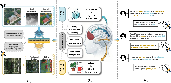
Figure 3: SatAgent’s architecture mirrors the dual visual pathway theory, combining global semantic priors (satellite) and local depth geometry (UAV) via a bidirectional and complementary dual-branch fusion and aligning representations for viewpoint-invariant reasoning.
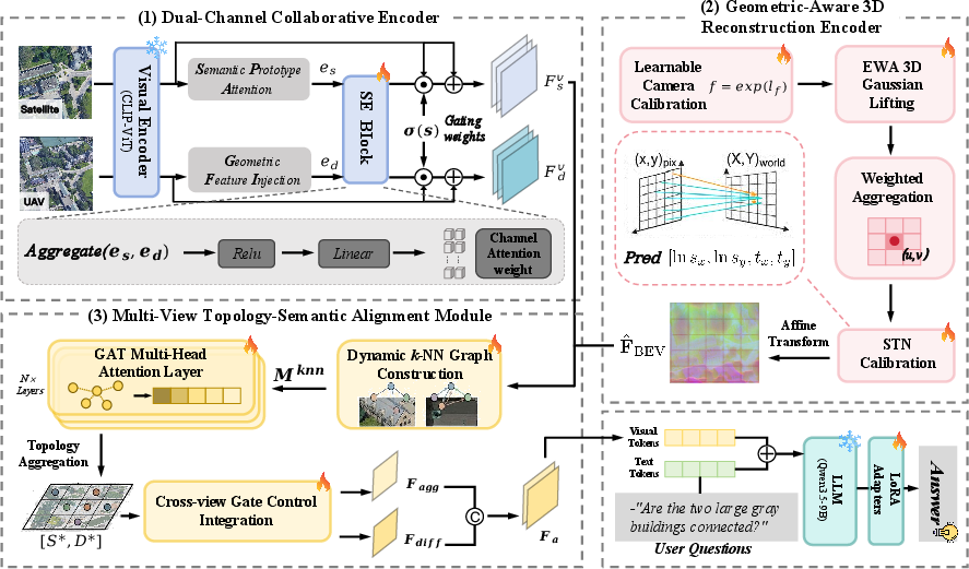
Figure 2: Overall architecture: dual-pathway encoding, geometry-aware 3D BEV reconstruction, dynamic topology-semantic alignment, and LLM-driven answer generation.
The geometric encoder and alignment modules are elaborated with detailed data flows in (Figure 4) and (Figure 5).
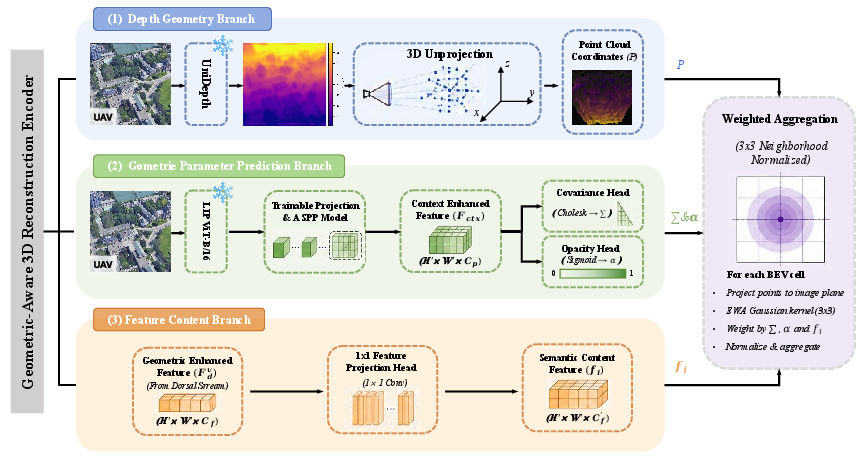
Figure 4: Geometry-aware encoder projects UAV camera imagery into BEV via learned calibration, depth, and soft 3D Gaussian projection with uncertainty.
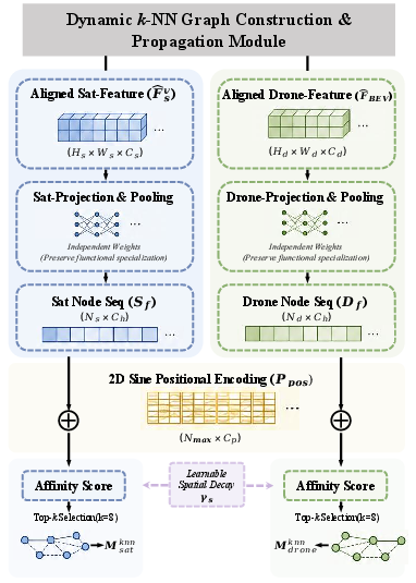
Figure 5: Dynamic k-NN graph attention module adaptively aligns topological and semantic information across perspectives for structured multi-view fusion.
SatAgent-SR130K: Dataset for Multi-View Spatial Reasoning
To evaluate cross-view spatial reasoning, the SatAgent-SR130K dataset is constructed, addressing the lack of benchmarks that demand genuine multi-view information fusion and disallow single-view shortcuts. The dataset comprises 130K VQA annotations spanning eight spatial reasoning categories, each designed to require both UAV and satellite perspectives. Directional references are unified by annotating all spatial terms in a canonical satellite-centric frame, mitigating ambiguity due to varying UAV view angles.
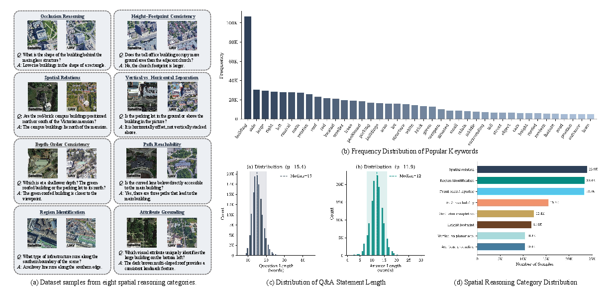
Figure 6: SatAgent-SR130K dataset overview: diverse reasoning categories, vocabulary and answer lengths, and category distributions.
Empirical Results and Ablation Analysis
Across four complementary metrics (Token F1, ROUGE-L, METEOR, BERTScore-F1), SatAgent exhibits strong improvements over existing closed- and open-source general VLMs as well as spatial reasoning specialty models. The Token F1 improvement achieved by SatAgent over the leading general-purpose VLM is +25.91%, and over the best existing dedicated spatial model is +11.69%. Particularly substantial gains are observed in reasoning categories most reliant on multi-view geometric consistency, such as cross-view spatial relations and path reachability.
Ablation studies confirm:
- The necessity of multi-view input: drone-only or semantic concatenation baselines perform substantially worse, especially for tasks such as global path reasoning and height-footprint consistency.
- The importance of explicit geometry modeling: removal of BEV coordinate calibration, depth estimation, or replacement of adaptive topology modeling each leads to marked performance drops, especially in categories requiring precise 3D correspondences.
- Functional specialization and cross-stream gating are critical: omitting the dual-pathway structure or the explicit specialization losses (geometric and orthogonality constraints) significantly degrades category-specific and overall accuracy.
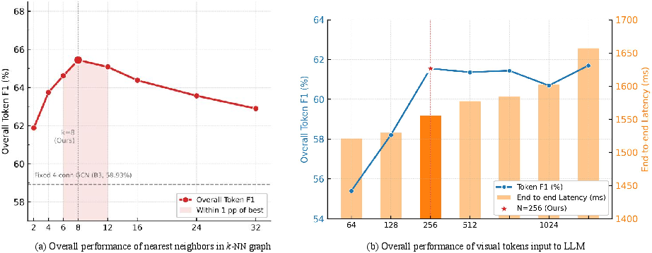
Figure 7: Hyperparameter sensitivity: optimum topological neighborhood (k) and token count for LLM input balance accuracy and inference cost.
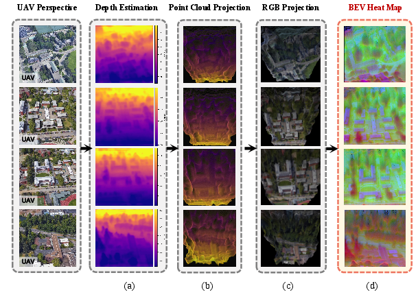
Figure 8: Geometry-aware encoding pipeline: depth prediction, calibrated back-projection, BEV soft-projection, and multi-channel geometric-appearance fusion enable accurate cross-view alignment.
Qualitative analyses reveal that SatAgent is robust in scenarios where generalist LLMs and monoperspective baselines fail, such as occlusion reasoning, fine-grained height-ordering, and path connectivity. However, performance degrades when spatial token compression becomes severe or temporal misalignment between satellite and UAV imagery introduces inconsistent scene structures.
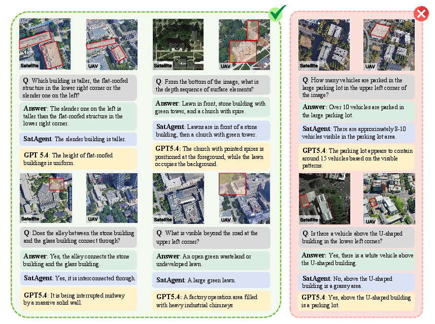
Figure 9: Qualitative comparison: SatAgent demonstrates robust multi-view 3D reasoning; GPT-5.4 fails under geometric ambiguity or occlusion; failure cases reveal SatAgent’s limits in dense or temporally mismatched scenes.
Practical and Theoretical Implications
The SatAgent approach demonstrates that introducing explicit, functionally separated modules for semantic and metric spatial reasoning—aligned in a coordinated BEV reference frame and fused through structured graph attention—significantly enhances spatial reasoning in vision-language tasks. The architecture closes a critical gap observed in both engineering-focused VLMs and cognitive modeling research, bridging global categorical priors with local 3D structure in a viewpoint-invariant fashion.
Practically, this work provides new directions for UAV mission planning, large-scale mapping, and autonomous navigation in urban or dynamic environments by capitalizing on the complementary sensing capabilities of low-altitude and orbital platforms. The approach also advances benchmarking: the SatAgent-SR130K dataset sets a new standard for evaluating collaborative spatial intelligence, requiring genuine fusion and eliminating shortcut exploitation common in previous datasets.
Theoretically, the results support the application of dual-stream cognitive models for embodied AI, justifying the explicit separation and coordination of semantic and geometric processing beyond implicit deep learning fusion. The role of dynamic graph-based topological alignment in establishing robust multi-view associations is substantiated at scale.
Future Research Directions
Several avenues emerge for further development:
- Adaptive Spatial Tokenization: Dynamic visual token allocation driven by local entropy can mitigate compression-induced errors in dense environments.
- Temporal Alignment: Modeling and adjusting for temporal disparities between cross-view images can enhance robustness to scene changes and semantic drift.
- Air–Space–Ground Integration: Extending the architecture to include ground-based and crowd-sourced data can generalize reasoning to “tri-perspective” spatial AI.
- Scalable Pretraining: Leveraging large-scale multi-perspective spatial corpora will be critical to further closing the gap to real-world operational settings and improving generalization to unfamiliar or adversarial configurations.
Conclusion
SatAgent constitutes a comprehensive framework for UAV-satellite collaborative spatial reasoning, rigorously addressing the fundamental limitations of single-perspective and monolithic VLMs in complex urban contexts. Through explicit dual-pathway encoding, geometry-aware 3D BEV reconstruction, and graph-based multi-view alignment, the model achieves state-of-the-art results on a purpose-built benchmark, providing both immediate practical value and deeper insights for embodied spatial AI research.